
Introduction
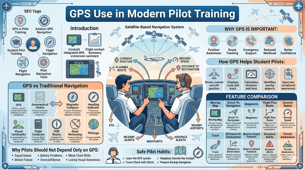
GPS has become an important part of modern pilot training. Today, student pilots use GPS to understand their aircraft position, route, ground speed, distance, track, estimated arrival time, nearby airports, and airspace around them.
The GPS use in modern pilot training helps beginners learn navigation more clearly. It gives pilots better situational awareness and supports safer flight planning. However, GPS should never replace basic pilot skills. A good pilot must still understand aeronautical charts, compass headings, visual landmarks, wind correction, VOR basics, and backup navigation.
For student pilots, GPS is a powerful learning tool. It helps them see how their planned route matches the actual flight path. It also helps instructors explain navigation mistakes, route corrections, and real-time decision-making.
This blog explains GPS in pilot training in simple language so that beginner pilots and aviation learners can understand how it works, why it matters, and how to use it safely.
What Is GPS in Aviation?
GPS stands for Global Positioning System. It is a satellite-based navigation system that helps pilots know the position of an aircraft.
In simple words, GPS receives signals from satellites and calculates where the aircraft is located. It can show the aircraft’s position on a moving map, along with the route, distance, speed, track, and destination information.
In aviation, GPS is used for:
- Route navigation
- Position awareness
- Flight planning
- Distance calculation
- Track monitoring
- Waypoint navigation
- Airspace awareness
- Emergency airport selection
For pilots, GPS is like a smart navigation assistant. It gives useful information, but the pilot must still think, cross-check, and make safe decisions.
Why GPS Is Important in Modern Pilot Training
GPS is important because it helps student pilots understand navigation in a visual and practical way. Instead of only imagining position on a map, students can see their aircraft location in real time.
Position Awareness
GPS helps pilots know where they are during flight. This is especially useful for student pilots who are still learning to connect chart information with the outside view.
Route Tracking
GPS shows whether the aircraft is following the planned route or drifting away due to wind. This helps students understand track correction.
Cross-Country Flight Training
During cross-country flights, GPS helps students monitor checkpoints, distance, estimated arrival time, and nearby airports.
Flight Planning
Pilots can use GPS to plan routes, add waypoints, review distance, and check airspace.
Emergency Support
If a pilot needs to divert, GPS can help identify the nearest suitable airport quickly.
Airspace Awareness
Many aviation GPS systems show airspace boundaries and alerts. This helps pilots avoid controlled or restricted areas.
Reduced Navigation Workload
GPS can reduce confusion during early navigation lessons. It gives students more time to focus on aircraft control, communication, and decision-making.
Better Confidence
When used correctly, GPS helps student pilots feel more confident. It supports learning and improves awareness during flight.
How GPS Helps Student Pilots
Student pilots are still building their navigation skills. GPS gives them a clear picture of where the aircraft is and how it is moving.
GPS helps student pilots in many ways.
Shows Current Aircraft Position
The moving map display shows the aircraft’s present location. This helps students compare the aircraft position with the planned route.
Displays Route and Track
GPS shows the planned route and the actual track of the aircraft. This helps pilots notice if wind is pushing the aircraft away from the route.
Calculates Distance and Time
GPS can show distance to the next waypoint, distance to destination, and estimated time of arrival.
Identifies Nearby Airports
The nearest airport function is helpful during training and emergency planning. It helps pilots quickly find airport options nearby.
Supports Diversion Planning
If weather changes or the destination is not suitable, GPS helps pilots choose a new airport and plan a route.
Improves Situational Awareness
Situational awareness means knowing what is happening around the aircraft. GPS improves awareness by showing airspace, route, nearby airports, and terrain information if available.
Reduces Early Navigation Confusion
Beginner pilots may feel overloaded during navigation lessons. GPS helps reduce confusion by giving clear position information.
Main Features of Aviation GPS
Modern aviation GPS systems may include many features. Student pilots should learn the basic features first.
Moving Map Display
A moving map display shows the aircraft position on a digital map. As the aircraft moves, the map updates.
This helps pilots see:
- Current position
- Route line
- Nearby airports
- Airspace boundaries
- Waypoints
- Terrain information if available
For students, this is one of the easiest ways to understand aircraft movement.
Direct-To Navigation
The “Direct-To” function allows a pilot to select a destination and get a direct route to it.
For example, if a pilot wants to go directly to a nearby airport, the GPS can show the heading, distance, and estimated time.
This feature is useful, but pilots should still check airspace, terrain, weather, and fuel before following the route.
Waypoints
A waypoint is a fixed point used for navigation. It can be an airport, navigation aid, reporting point, or GPS position.
Pilots use waypoints to build a route. A route may include departure airport, checkpoints, navigation points, and destination airport.
Flight Plan Route
A GPS flight plan route is a planned path entered into the system. It may include several waypoints.
The GPS then helps the pilot follow that route and monitor progress during flight.
Ground Speed
Ground speed is the aircraft’s speed over the ground. It may be different from airspeed because of wind.
GPS shows ground speed, which helps pilots estimate arrival time and fuel planning.
Track
Track means the actual path the aircraft is following over the ground. Heading means the direction the aircraft nose is pointing.
Wind can make the track different from the heading. GPS helps students understand this difference clearly.
Distance to Destination
GPS shows how far the aircraft is from the destination or next waypoint. This helps pilots monitor flight progress.
Estimated Time of Arrival
Estimated Time of Arrival, or ETA, tells the pilot when the aircraft may reach the destination based on current ground speed.
This is useful for fuel planning, communication, and flight management.
Nearest Airport Function
The nearest airport function shows airports close to the aircraft’s current position.
This is very useful during emergencies, bad weather, or diversion training.
Airspace Alerts
Some GPS systems provide alerts when the aircraft is approaching controlled or restricted airspace.
These alerts help pilots remain aware, but pilots must still study charts before flight.
Terrain Awareness
Some aviation GPS systems show terrain information. This can help pilots identify higher ground nearby.
However, terrain awareness should support safe flying, not replace proper altitude planning.
GPS Feature Comparison Table
| GPS Feature | Main Use | Student Pilot Benefit |
|---|---|---|
| Moving Map | Shows aircraft position on a map | Helps understand location clearly |
| Direct-To | Gives direct route to selected point | Useful for diversion and route correction |
| Waypoints | Creates navigation points | Helps build planned routes |
| Flight Plan Route | Shows complete route | Supports cross-country training |
| Ground Speed | Shows speed over ground | Helps estimate time and fuel |
| Track | Shows actual ground path | Helps understand wind drift |
| Distance to Destination | Shows remaining distance | Helps monitor progress |
| ETA | Shows estimated arrival time | Supports planning and communication |
| Nearest Airport | Finds nearby airports | Useful for emergency planning |
| Airspace Alerts | Warns about nearby airspace | Improves airspace awareness |
| Terrain Awareness | Shows terrain risk if available | Supports safer altitude awareness |
GPS and Flight Planning
GPS is useful before the aircraft even leaves the ground. During flight planning, pilots can enter and review the route carefully.
Here is a simple process.
1. Select Departure Airport
The pilot enters the airport where the flight will begin.
2. Select Destination Airport
The pilot enters the destination airport and checks distance and route direction.
3. Add Waypoints
Waypoints help divide the route into smaller parts. This makes navigation easier.
4. Review Airspace
The pilot checks if the route passes through controlled, restricted, or special-use airspace.
5. Check Distance and Time
GPS gives distance and estimated time, but pilots should also understand manual calculations.
6. Review Fuel Planning
GPS can support fuel planning by showing estimated time, but the pilot must calculate fuel properly using aircraft performance data.
7. Identify Alternate Airports
Pilots should always know where they can land if the destination becomes unsuitable.
8. Check Terrain and Obstacles
The route should be reviewed for high terrain, towers, and obstacles.
9. Prepare Backup Navigation
A pilot should also prepare charts, compass headings, visual checkpoints, and radio navigation if available.
10. Review the Route Before Takeoff
Before takeoff, the pilot should confirm that the route is entered correctly and matches the planned flight.
GPS During Cross-Country Training
Cross-country training is an important part of pilot training. It teaches students how to plan and fly from one airport to another.
GPS helps during cross-country training by showing:
- Aircraft position
- Planned route
- Ground track
- Distance remaining
- Estimated arrival time
- Nearby airports
- Airspace boundaries
- Route deviation
For example, if wind pushes the aircraft away from the planned route, GPS makes it easy to see the drift. The student can then correct the track with instructor guidance.
GPS also helps students confirm checkpoints. If a student expects to see a river or town at a certain time, GPS can help verify whether the aircraft is on schedule and on route.
However, instructors often encourage students to practice without looking at GPS too much. This helps build traditional navigation skills and outside visual awareness.
GPS vs Traditional Navigation
GPS is modern and powerful, but traditional navigation is still necessary. Student pilots should learn both.
| Navigation Method | Main Purpose | Why It Matters |
|---|---|---|
| GPS | Shows real-time position and route | Helps with awareness and route tracking |
| Aeronautical Charts | Shows airports, airspace, terrain, and obstacles | Builds complete route understanding |
| Magnetic Compass | Shows direction | Works as a basic backup |
| Heading Indicator | Helps maintain heading | Supports stable directional control |
| Visual Landmarks | Confirms position using outside references | Builds real flying awareness |
| Flight Computer | Calculates time, speed, fuel, and wind correction | Builds planning skill |
| VOR | Provides radio navigation support | Useful as backup and training tool |
| Dead Reckoning | Uses heading, speed, time, and wind | Builds strong manual navigation thinking |
| Pilotage | Uses landmarks for navigation | Improves visual navigation confidence |
GPS is very useful, but traditional methods teach the pilot how to think, plan, and cross-check.
Why Pilots Should Not Depend Only on GPS
GPS is helpful, but depending only on GPS can be unsafe. A pilot must always be prepared for GPS problems or wrong use.
GPS Signal Issues
Signals may sometimes become weak or unreliable. Pilots should know what to do if GPS accuracy becomes poor.
Device Failure
A GPS unit or tablet can fail. Screens can freeze, systems can restart, or equipment can stop working.
Battery Problems
Portable devices depend on battery power. If the battery dies, the pilot needs backup tools.
Database Errors
A GPS database must be current and correct. Outdated data can create navigation risks.
Overconfidence
Some pilots may trust GPS too much and stop checking charts or outside landmarks.
Poor Chart Reading Skills
If a student always follows GPS, they may not develop strong chart reading skills.
Weak Situational Awareness
Looking only at the GPS screen can reduce outside awareness. Pilots must continue scanning outside and monitoring instruments.
Lack of Backup Planning
Safe pilots always prepare backup navigation. GPS should never be the only plan.
Traditional Skills Student Pilots Must Still Learn
Modern pilot training includes GPS, but it also requires traditional navigation skills.
Aeronautical Chart Reading
Pilots must understand airports, airspace, terrain, obstacles, and navigation aids shown on charts.
Compass Headings
Student pilots must understand directions, headings, and how to fly a planned heading.
Visual Navigation
Visual navigation means using landmarks such as roads, rivers, towns, lakes, and coastlines to confirm position.
Dead Reckoning
Dead reckoning uses heading, speed, time, and wind correction to estimate position.
Pilotage
Pilotage means navigating by looking outside and comparing visible landmarks with the chart.
VOR Basics
VOR teaches radio navigation and helps pilots understand route tracking without GPS.
Time and Distance Calculation
Pilots must know how to estimate travel time, distance covered, and fuel required.
Wind Correction
Wind can push an aircraft away from its planned route. Pilots must learn how to correct for wind drift.
Airspace Reading
Pilots must understand airspace boundaries and rules before entering any area.
Radio Communication
Communication with air traffic control helps pilots get clearances, traffic information, and route support.
GPS as a Support Tool, Not a Replacement
GPS should support pilot decision-making. It should not replace pilot thinking.
A safe pilot cross-checks GPS information with:
- Aeronautical charts
- Outside landmarks
- Compass heading
- Heading indicator
- Flight plan
- Radio navigation aids
- Airspace information
- Weather conditions
- Instructor guidance during training
For example, if GPS shows that the destination is 30 minutes away, the pilot should still check fuel, weather, airspace, and alternate options. GPS gives information, but the pilot makes decisions.
This is one of the most important lessons in modern pilot training.
Common GPS Mistakes Beginner Pilots Make
Student pilots can make mistakes while using GPS. These mistakes are common during training, but they must be corrected early.
Following GPS Without Checking Charts
GPS may show a route, but the pilot must check airspace, terrain, obstacles, and restrictions on charts.
Entering the Wrong Waypoint
A small typing mistake can send the aircraft toward the wrong location. Always verify waypoints before takeoff.
Ignoring Airspace Warnings
Some students see alerts but do not fully understand them. Airspace warnings must be taken seriously.
Forgetting to Update the Database
Outdated GPS data may show old airport, airspace, or navigation information.
Not Checking Battery or Power Source
Portable GPS devices or tablets need enough power for the flight. Backup power should be considered.
Looking at the Screen Too Much
Pilots must not spend too much time looking inside the cockpit. Outside scanning is essential.
Losing Visual Awareness
GPS can make students forget to look for landmarks. Visual navigation should still be practiced.
Not Preparing Backup Navigation
Every navigation flight should have a backup plan.
Misunderstanding GPS Track and Heading
Track is the path over the ground. Heading is where the aircraft nose is pointing. Wind can make them different.
Trusting GPS Without Cross-Checking
A safe pilot always confirms GPS information with other sources.
Best Practices for GPS Use in Pilot Training
GPS is most useful when used properly. Student pilots should follow safe habits from the beginning.
Learn the GPS System Before Flight
Do not try to understand a new GPS system for the first time in the air. Learn buttons, menus, and basic functions on the ground.
Enter Routes Carefully
Check every waypoint and airport code before takeoff.
Cross-Check GPS With Charts
Always compare GPS information with aeronautical charts.
Keep Aviation Data Updated
Use current aviation data whenever GPS is used for flight planning or navigation.
Use GPS for Awareness, Not Dependency
GPS should help you understand the flight, not replace your navigation skills.
Practice Navigation Without GPS Sometimes
With instructor approval, practice using charts, compass, landmarks, and time calculations.
Keep Eyes Outside the Cockpit
Especially during visual flight, pilots must continue looking outside for traffic, landmarks, weather, and terrain.
Prepare Backup Tools
Carry or prepare backup charts, headings, frequencies, and alternate airport information.
Review GPS Settings Before Takeoff
Check units, route, alerts, map scale, and power source before flight.
Ask Instructors for Real Scenarios
Instructors can teach how to use GPS during diversions, airspace avoidance, route changes, and emergencies.
Beginner-Friendly Example of GPS Use During Training
Imagine a student pilot planning a short training flight from Airport A to Airport B.
Before takeoff, the student enters the departure airport, destination airport, and two waypoints into the GPS. The instructor asks the student to compare the GPS route with the aeronautical chart.
The student checks the route and notices controlled airspace near the planned path. The instructor explains how to remain outside that airspace or contact air traffic control if required.
During the flight, the GPS shows the aircraft slightly right of the planned route. The instructor asks the student to look outside and identify a nearby river and highway. The student confirms the position using both the GPS and visual landmarks.
Later, the instructor asks, “What would you do if the destination weather became poor?” The student uses the GPS nearest airport function to find a suitable alternate airport. Then the student checks the chart and radio frequency before planning the diversion.
This example shows that GPS is helpful, but the student still uses charts, landmarks, airspace awareness, and instructor guidance.
GPS Use Checklist for Student Pilots
Before using GPS during a training flight, student pilots can follow this checklist.
Before Flight
- GPS database checked
- Device or aircraft GPS powered properly
- Route entered correctly
- Departure airport verified
- Destination airport verified
- Waypoints reviewed
- Airspace checked
- Terrain and obstacles reviewed
- Alternate airport selected
- Frequencies written down
- Backup chart ready
- Power source checked
- Instructor briefing completed
During Flight
- Route monitored
- Track checked
- Ground speed reviewed
- ETA checked
- Airspace alerts monitored
- Outside landmarks confirmed
- Fuel and time cross-checked
- GPS information compared with chart
- Backup plan kept ready
After Flight
- Route performance reviewed
- Navigation mistakes discussed
- GPS use evaluated
- Traditional navigation skills practiced again
- Instructor feedback noted
How GPS Builds Better Situational Awareness
Situational awareness means knowing where the aircraft is, what is around it, and what may happen next.
GPS helps build situational awareness by showing:
- Current position
- Nearby airports
- Airspace boundaries
- Distance to destination
- Estimated arrival time
- Ground speed
- Route deviation
- Nearby terrain if available
However, true situational awareness comes from combining GPS with pilot thinking. A student pilot should ask:
- Am I on the planned route?
- Is my track correct?
- What airspace is ahead?
- What airport is nearby?
- Is weather affecting my route?
- Do I have enough fuel?
- What is my backup plan?
GPS gives information. The pilot must understand and use that information wisely.
Role of GPS in Emergency Training
GPS can be very useful during emergency training. If a pilot needs to land quickly, GPS can help identify nearby airports.
The nearest airport function may show:
- Airport distance
- Direction
- Runway information
- Frequency details
- Estimated time to reach
This can save time during high workload situations. However, the pilot must still check whether the airport is suitable. Runway length, wind, terrain, aircraft condition, and weather must all be considered.
GPS supports emergency decisions, but it does not make the full decision for the pilot.
GPS and Instructor-Led Learning
Flight instructors play an important role in teaching GPS use. They help student pilots understand when to use GPS, when to look outside, and when to use traditional navigation.
An instructor may teach students how to:
- Enter a flight plan
- Use waypoints
- Check nearest airports
- Understand track and heading
- Avoid airspace
- Cross-check with charts
- Use GPS during diversion
- Avoid screen dependency
- Manage cockpit workload
Good GPS training is not just about pressing buttons. It is about safe decision-making.
FAQs About GPS Use in Modern Pilot Training
1. What is GPS use in modern pilot training?
GPS use in modern pilot training means teaching student pilots how to use satellite-based navigation for position awareness, route tracking, flight planning, airspace awareness, and emergency support.
2. Do student pilots need to learn GPS?
Yes, student pilots should learn GPS because it is widely used in modern aviation. However, they must also learn traditional navigation skills.
3. Can pilots fly only using GPS?
Pilots should not depend only on GPS. They must also understand charts, compass headings, visual landmarks, airspace, and backup navigation.
4. Why is GPS important in cross-country training?
GPS helps student pilots monitor route, distance, ground speed, estimated arrival time, checkpoints, and nearby airports during cross-country flights.
5. What is a waypoint in GPS navigation?
A waypoint is a fixed navigation point used to build a route. It may be an airport, navigation aid, reporting point, or GPS location.
6. What is the difference between GPS track and heading?
Heading is the direction the aircraft nose is pointing. Track is the actual path the aircraft follows over the ground. Wind can make track and heading different.
7. Why should pilots still learn chart reading?
Pilots need chart reading to understand airspace, airports, terrain, obstacles, navigation aids, and route planning. GPS alone does not replace chart knowledge.
8. What happens if GPS fails during flight?
If GPS fails, the pilot should use backup navigation methods such as charts, compass headings, visual landmarks, VOR if available, and ATC support.
9. How can student pilots avoid GPS dependency?
Student pilots can avoid GPS dependency by practicing chart reading, visual navigation, dead reckoning, compass use, and route planning without always relying on GPS.
10. Is GPS useful for emergency situations?
Yes, GPS can help pilots quickly find nearby airports, check direction and distance, and support diversion planning during emergencies.
Conclusion
The GPS use in modern pilot training has made aviation navigation easier, clearer, and more practical for student pilots. GPS helps with position awareness, route tracking, cross-country flying, distance calculation, airspace alerts, and emergency planning.
However, GPS should be used as a support tool, not as a replacement for pilot knowledge. A safe pilot must still understand aeronautical charts, compass headings, visual landmarks, dead reckoning, VOR basics, wind correction, radio communication, and backup planning.
For beginner pilots, the best approach is to learn GPS along with traditional navigation. This balanced training builds confidence, safety, and better decision-making in the cockpit.
Modern GPS technology is powerful, but the most important navigation tool is still a well-trained pilot who understands how to think, cross-check, and fly safely.
